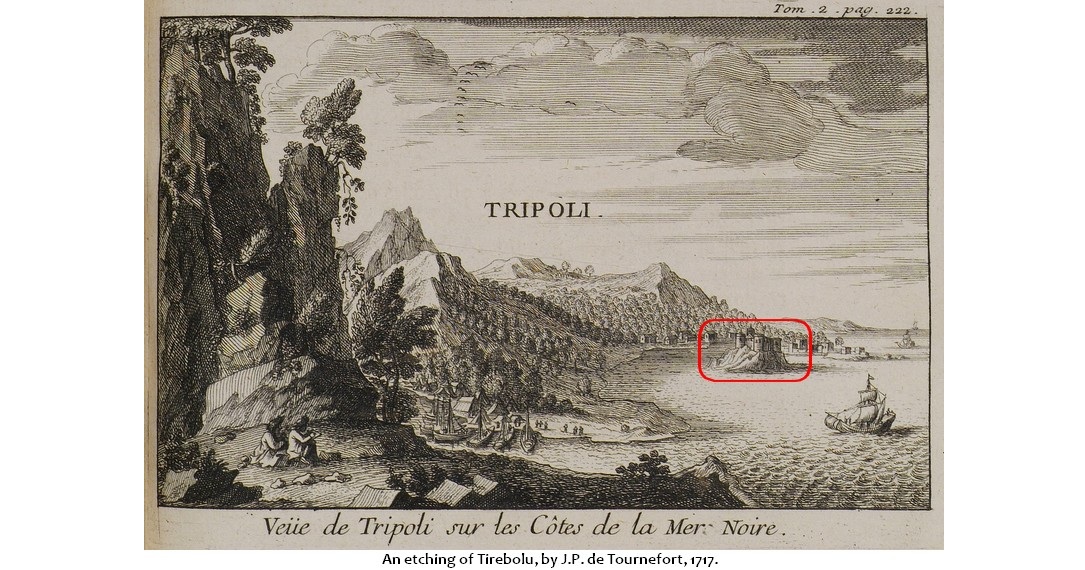
Plate 1: Tirebolu (Tournefort 1717) Source
History of Tirebolu (Tripolis), Pontos1
Sam Topalidis 2025
(Pontic Historian and Ethnologist)
Introduction
Tirebolu (formerly Tripolis) is a small town on the southern Black Sea coast (Fig. 1; Plates 1–2) in north-east Türkiye (Pontos), 7 km west of the mouth of the Harşit River and 90 km west of Trabzon. The Harşit River runs 76 km north-west from Torul (south-west of Trabzon, Fig. 1). Tirebolu probably had indigenous Anatolians living there when it was settled by Greeks sometime after 400 BC. The town is clustered on and behind three rocky promontories which probably gave rise to its name—Tripolis in Greek means ‘three cities’ (Bryer and Winfield 1985).
History
Pontos
Although the army of Alexander the Great (336–323 BC) defeated the Persians in Anatolia, the Greeks did not march north to conquer the Black Sea coast. These areas however, accepted his authority (Şerifoğlu and Bakan 2015). In 302 BC, Mithradates I, of Persian descent, established the kingdom of Pontos along part of the southern Black Sea coast (Roller 2020). Mithradates and kings from the same family ruled over the area west of Sinope and east to Trabzon until Mithradates VI2 was defeated by the Romans in 64 BC (Erciyas 2001).
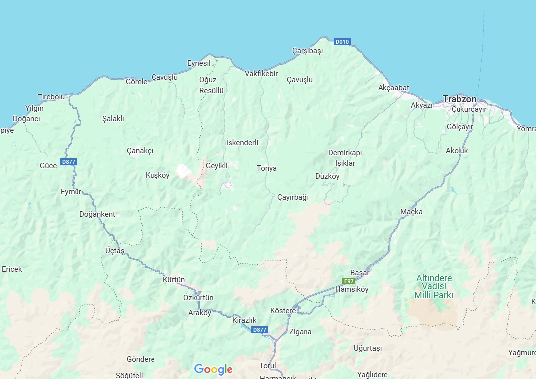
Fig. 1: Giresun to Trabzon, north-east Turkiye (Tirebolu to Trabzon = 80 km, Source
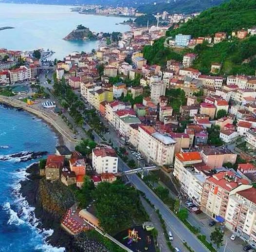
Plate 2: Tirebolu Source
Pontos became part of the Roman empire in the 60s AD (Roller 2020). Later, with the division of the Roman empire, it became part of the Eastern Roman (Byzantine) empire. As a result of the Fourth Crusade’s sacking of Constantinople in 1204, the small independent Komnenoi Byzantine empire of Trebizond (1204–1461) in north-east Anatolia was formed. Tirebolu formed the border between the Komnenoi empire of Trebizond and the Turkmen. Ottoman sultan, Mehmed II probably took over Tirebolu during his return to Constantinople after Trabzon surrendered to him in 1461.
Tirebolu
The eastern and western promontories of Tirebolu were fortified. From 1204, the Grand Komnenoi of Trabzon regarded the eastern castle as a safe refuge (Plate 3) while the western castle was not built until after 1461. The Harşit River and flanking districts of the valley had fallen into the hands of the Çepni by the 14th century,3 leaving the Komnenoi Greeks only the coast and the castles of Petroma and Torul at either end of the valley (Bryer and Winfield 1985:140).
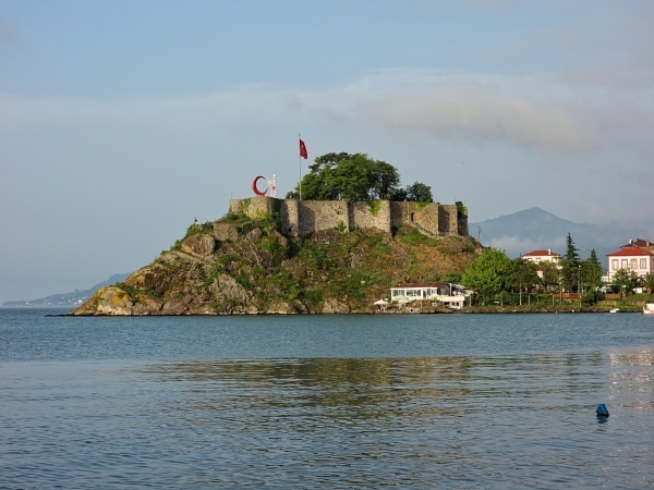
Plate 3: Tirebolu eastern castle. Source
The ruined Petroma castle stands on a summit about 400 m above the east side of the Harşit River. Located 5 km to the south of the mouth of the river, it oversaw any threat to the mines at Argyria which may have been exploited in the later Middle Ages (Bryer and Winfield 1985). [Some ruins can still be found on the summit.]4 The silver mine at Argyria was operating up to around 1800 (Hamilton 1842).
From the 16th century, the Pontic Greeks of Tirebolu were concentrated to the north of the Turkish quarter (near the eastern castle). The Armenian community was located around the Armenian church, near the commercial centre on the coast (Kertmenjian 2009:210).
In 1816, rebellion affected the region when Kel Ali-oğlu Ali Ağa took temporary control of Tirebolu. However, in October, an Ottoman military force regained control (See).
In December 1914, during World War I, the Russian fleet shelled Tirebolu. In June 1915, the displacement of its Armenian residents [genocide] began (Öztürkmen 2006).
In November 1916, (after the Russian invasion of north-eastern Anatolia) the Ottoman army used the encampment of the Russian army near the mouth of the Harşit River as an opportunity to do away with the Pontic Greeks in Tirebolu and Giresun. Claiming that there was a possibility of collaboration between Pontic Christians and Russians, they began to deport the Greeks. Thus, around 3,000 Orthodox Christians5 were marched from Tirebolu to Birk, an abandoned Armenian village [the Armenians had been slaughtered by the Turks]. Four months after having been settled there, an epidemic broke out. Later, they moved to Russia and in 1919, many of them left Russia for Greece (Fotiadis 2019:182–183).
Greek Churches
In the late 19th century, there were eight mosques, two Greek Orthodox churches and one Armenian church in Tirebolu. Tsimida was the most important Pontic Greek area of the town where the Greek church dedicated to the Archangel Michael was located. There were also five old dilapidated Greek chapels (See Cuinet 1892:54–55). The other church was the Ζωοδόχου Πηγής [‘Life Giving Spring’] (Lazaridis 1988). In the 1930s, one of the Greek churches was converted into a movie theatre (Öztürkmen 2024).
Population
From the 15th to the 18th century, there was no great increase in population. In the early years of the Ottoman rule (post 1461), there were only Christian Greek inhabitants and by 1640, Tirebolu was a town which still had a Greek Orthodox majority. Unfortunately, there is no information on the population of Tirebolu in the 18th century when many [Pontic Greek] immigrant mine workers from Chaldia [area around Gumushane about 100 km south of Trabzon] settled in Tirebolu and other towns. The local Pontic Greeks of Tirebolu spoke Romeyka [Greek dialect]6 which resembled the Romeyka of Gumushane but differed from the Romeyka spoken in Giresun (See).
Cuinet (1892:53)7 reported that in 1890, ‘around’ 8,000 people lived in Tirebolu of whom 5,600 (or 70%) were Muslim, 2,000 (or 25%) Greek Orthodox and 400 (or 5%) Armenian. According to the more reliable 1910–1912 Greek population data from the Ecumenical Patriarchate of Constantinople, there were 11,875 Pontic Greeks in the county8 of Tirebolu (Alexandris 1999:64). By the end of the war, according to Maccas (1919:82), the county of Tirebolu was inhabited by 49,530 people of whom 17,820 (or 36%) were Greeks and 710 Armenians.
In July 1921, (after World War I) of the around 2,500 Greeks in the town, only 200 women and children remained (Central Council of Pontus 1922).
Economy
In Tirebolu there was no road connecting the town with the interior of Anatolia and up until 1820, access to Tirebolu was via boats. By the mid-19th century, wine was the most important export but by circa 1856, they started to cultivate hazelnuts which replaced wine in importance. In the 19th and early 20th centuries, many Pontic Greek fishermen from Tirebolu went to Russia for six months each year, specifically to Crimea to work in plants producing salted fish. Hemp also yielded significant income for the inhabitants making ropes and textiles and indeed, the textile industry, based on hemp was widespread until World War I (See).
In the late 19th century, [most probably between the late 1880s and 1890] the annual yield of major agricultural products was estimated on average as follows: hazelnuts (4.5 million kg), beans (600,000 kg), corn (500,000 kg) and rice (450,000 kg) (Cuinet 1892:57).
Administration
In the 19th century, there was a seven-member council consisting of four Muslims, two Greeks and one Armenian. The Greeks paid the community a ‘school levy’ which assisted the poor and the sick. In 1908, the Greek youth of Tirebolu established the Greek Educational Association ‘Odyssey’ to disseminate education among young people and assist the poor of the town (See).
Education
In 1870, the first Pontic Greek boy’s school was established. The elementary Greek school of the town was probably built in the late 19th century founded by Kyriakos Xenopoulos, near the church of the ‘Life Giving Spring’. In 1905, there was a seven-grade boy’s Greek school and a five-grade girl’s Greek school with six teachers and 350 pupils (Lazaridis 1988).
Tirebolu Today
Tirebolu has an estimated population of 20,700 (2022) with the Tirebolu district comprising 48 villages has an estimated population of 32,600 (2022) (See). The seaside road, constructed in the early 1950s, shifted the local market to the seaside called Barabut. In the 1990s, an artificial harbour was constructed, followed by the filling of the old bay at Barabut thus creating more land for the town. In the 2010s, new high rise-housing projects with sea views emerged which expanded the town (Öztürkmen 2024).
In addition to fishing, trout farming and beekeeping have developed in recent years while tea, hazelnut cracking and lumber factories continue to operate along with some copper mining (See).
Acknowledgements
I warmly thank Michael Bennett, Russell McCaskie and Aris Tsilfidis for their comments to an earlier draft.
References
1. This article suffers from the lack of available reliable information in English.
2. The kingdom of Mithradates VI encompassed areas around the Black Sea and within Anatolia. See the author’s article at: www.pontosworld.com/index.php/history/sam-topalidis/896-mithradates-vi-king-of-pontos
3. The Çepni were a clan of Turkmen who entered Anatolia with the Seljuk Turks in the 11th century (Kennedy 2019).
4. Words within square brackets ‘[ ]’ are the author’s words.
5. In Fotiadis (2019) it was incorrectly stated that it was 13,000 Orthodox Christians, this was a typographical error.
6. See the author’s article on Romeyka at: www.pontosworld.com/index.php/history/sam-topalidis/892-romeyka-an-endangered-greek-dialect
7. Cuinet used Ottoman data of limited quality to create his figures.
8. Ottoman provinces were divided into districts (sanjaks) which were further divided into counties (kazas).
Sources
Alexandris A (1999) ‘The Greek census of Anatolia and Thrace (1910–1912): a contribution to Ottoman historical demography’, in Gondicas D and Issawi C (eds) (1999):45–76, Ottoman Greeks in the age of nationalism, The Darwin Press Inc., Princeton, New Jersey.
Bryer A and Winfield D (1985) The Byzantine monuments and topography of the Pontos, I, Dumbarton Oaks Research Library & Collection, Harvard University, Washington DC.
Central Council of Pontus (1922) Black Book: the tragedy of Pontus: 1914–1922, Central Council of Pontus, Athens.
Cuinet V (1892) La Turquie d'Asie geographie administrative statistique descriptive et raisonnee de chaque province de L’Asie Mineure [in French], [The Asian Türkiye administrative geography: statistical description and reasoning of each province of Asia Minor] Paris.
Erciyas DBA (2001) ‘Studies in the archaeology of Hellenistic Pontus: the settlements, monuments, and coinage of Mithradates VI and his predecessors’, PhD thesis, University of Cincinnati, USA.
Fotiadis KE (2019) The genocide of the Pontian Greeks, (unknown translator into English), KE Fotiadis, (Place of publication not stated).
Hamilton WJ (1842) Researches in Asia Minor, Pontus and Armenia: with some account of their antiquities and geology, 1, (originally published by John Murray, London), reprinted 2009.
Kennedy S (ed) (2019) Two works on Trebizond: Michael Panaretos, Bessarion, (translated by Kennedy S), Dumbarton Oaks Medieval Library, Harvard University Press, Cambridge Massachusetts.
Kertmenjian D (2009) ‘Armenian city quarters and architectural legacy of the Pontus’,:189–215, in Hovannisian RG (ed) (2009) Armenian Pontus: the Trebizond-Black Sea communities, Mazda Publishers Inc, Costa Mesa, California.
Lazaridis D (1988) Στατιστικοι πινακες της εκπαιδεύσεως των Eλληνων στον Ποντο 1821–1922 (in Greek), [Statistical list of Greek schools in the Pontos 1821–1922], Archeion Pontou [Archives of Pontos] 16, Epitropi Pontiakon Meleton, [The Committee for Pontic Studies] Athens.
Maccas L (1919) L'hellenisme de l'Asie Mineure, [Hellenism in Asia Minor, in French], Nancy, Paris.
Öztürkmen A (2006) ‘Remembering conflicts in a Black Sea town: a multi-sited ethnography of memory’, New Perspectives on Turkey, 34:93–114.
Öztürkmen A (2024) ‘Goods and gaiety in a Turkish Black Sea town: oral history of women in Tirebolu’, in Krawietz B and Gauthier F (eds) (2024) The Routledge handbook of global Islam and consumer culture,:138–155, Routledge, London.
Roller DW (2020) Empire of the Black Sea: the rise and fall of the Mithridatic world, Oxford University Press, New York.
Şerifoğlu TE and Bakan C (2015) ‘The Cide-Şenpazar region during the Hellenistic period (325/300–1 BC)’, in Düring BS and Glatz C (eds) (2015), Kinetic landscapes: the Cide archaeological project: surveying the Turkish western Black Sea region,:246–259, De Gruyter Open, Warsaw, Poland.
Tournefort JP de (1741) A voyage into the Levant, III, letter v, (translated from French to English by Ozell J), published 1718, London.