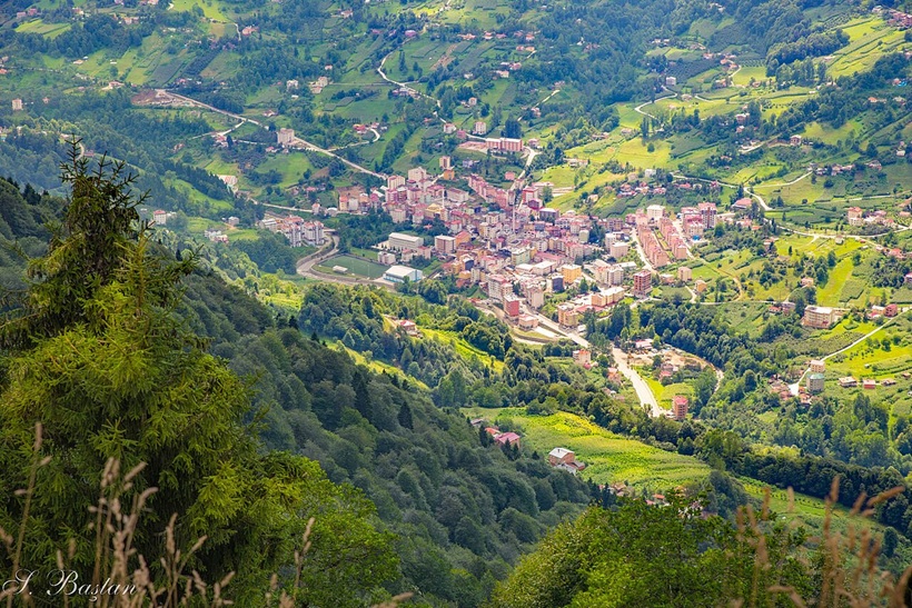
 Plate 1: Tonya, northern Türkiye (2023, Wikimedia Commons)
Sam Topalidis (2026)
(Pontic Historian and Ethnologist)
Introduction
Tonya’s origin (Byzantine Thoania) and history are one of the puzzles of Pontos (north-east corner of Anatolia near the Black Sea). When Tonya was first settled, most probably by Greeks, is unknown. Tonya lies about 750 m above sea level where the valley widens out, forming gentle sloping agricultural land, around 70 km (by road) south-west from Trabzon (Fig. 1; Plate 1). Precipitation in Tonya averages 1,200–1,500 mm annually with summer temperature highs rarely exceeding 25°C and winter lows averaging around 5°C (Bryer and Winfield (1985:155); Source).
The Tonya district covers 264 km² of generally rugged terrain. The Fol Stream flows north through Tonya to the Black Sea (Source). It is isolated country and the people from Tonya had a reputation for vendetta and assassination (Note 1) Bryer and Winfield (1985:155).
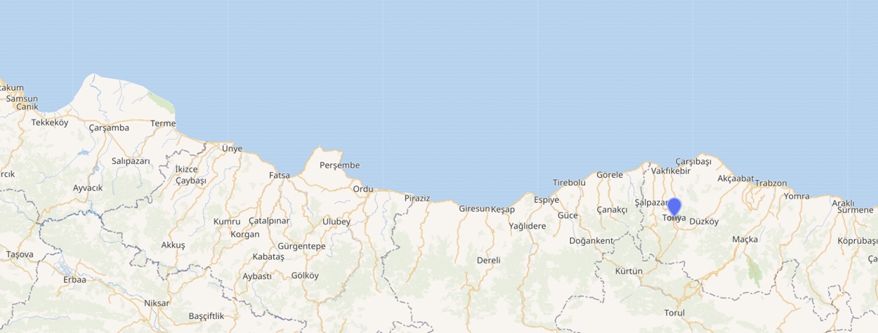 Fig. 1: Location map of Tonya, northern Türkiye (Tonya to Trabzon = 40 km; https://tr.wikipedia.org)
History
From the 7th century BC, Greeks, especially from Miletos (on the west coast of Anatolia) helped to establish colonies along the Black Sea coast, including Pontos. (There were native Anatolians also living in Pontos.) When the army of Alexander the Great (reign 336–323 BC) defeated the Persians in Anatolia, the Greeks did not march north to conquer the Black Sea coast although these areas accepted his authority (Şerifoğlu and Bakan 2015). In c.302 BC, Mithradates, of Persian descent, established the kingdom of Pontos. Mithradates and kings from the same family ruled over the area from Heraclea (west of Sinope) east to Trabzon on the southern Black Sea coast until the reign of Mithradates VI who was defeated by the Romans in 64 BC. The kingdom of Mithradates VI, which encompassed Pontos and other areas around the northern and eastern Black Sea area and parts of Anatolia, was eventually absorbed within the Roman empire in the 60s AD (Roller 2020). In the 4th century, Anatolia became part of the Eastern Roman (Byzantine) empire. In 1204, Alexios and David Komninos left Constantinople and with troops provided by their aunt, queen Thamar from Georgia, seized Trabzon from the Byzantines (Note 2). In 1204–1461, the Komnenoi emperors of the small empire of Pontos controlled Trabzon and an area along the Pontic coastline (which included Tonya). In 1461, emperor David Komnenos surrendered Trabzon to the Ottoman sultan Mehmed II and Tonya then fell into Ottoman hands.
At the turn of the 17th and 18th centuries, the Greek communities of Tonya threw in their lot with the feudal lords (derebeys, see Note 3) (Bryer 1970). The [early]1 19th century was a period of dominance by these lords. In Tonya, the most important of these lords was Ali Ağa, who maintained a private army (Sourcei).
The 1903 yearbook states that the inhabitants of Tonya were engaged in agriculture (corn, beans, hemp, butter, honey, beeswax, cheese and eggs), blacksmithing, stonemasonry, carpentry and mule-herding and they were famous for their marksmanship. At that time, the central district and its 20 affiliated villages had a total of 2,455 houses [around 12,275 people] (Source/).
On 16 July 1916, during World War I, Tonya was occupied by the Russian army. The battle to take Tonya seems to have been very fierce. The Russian occupation ended on 17 February 1918 (Brendemoen 2002:32). Life in the greater Trabzon area during the Russian occupation was a difficult time with the prevalence of diseases, armed bandits and a lack of food.
Prior to the 1923 population exchange between Greece and Turkey, Tonya comprised 2,000 Romeyka Greek speaking Islamised families (Note 4) (Source).
Historic Buildings
Church
The town of Tonya has no antiquities. Higher up the Fol valley to the south, there were iron mines and 12 km south of Tonya at Kalinçam,2 there is a ruined Byzantine church (name unknown) with no roof (Fig. 2). The church had two identical apses [today no apses are standing]. Much stone had been robbed from the site. Lying near the church, a number of fragments of flat tiles were found. In the church the remains of painted plaster in two layers were evident. The construction of the walls may indicate a Middle Byzantine date, but the two layers of plaster for the wall paintings suggest a 13th up to the 12th century date. Near this church there was a han (overnight inn) which strongly suggests the use of this valley as a route across the mountains (Bryer and Winfield 1985:47, 153, 159).
Castle
The Ali Ağa Castle ruins are located in the Kaleönü neighbourhood of Tonya. It is a natural defensive structure consisting of four large rocks. It is accessible via steps carved into the cliffs. The castle contains water cisterns and battlements [that are difficult to see]. It was used by Ali Ağa (1776–1844), a feudal lord in the region (Source).
Romeyka Greek Dialect
In Tonya, the once common Romeyka Greek dialect is dying out, but (in the 1980s) there were Romeyka speakers in the surrounding Tonya villages of Keşli, Tumasli, Pahartirli, Beşkeli, Mamali, Tsuluk, Melikshah and Ağirköy (Source). The author is unsure of the exact location of most of these villages. Most probably, they had Pontic Greek Christian ancestors who converted to Islam possibly in the late 17th-century, although there is no popular story of why this happened. The Muslim population may have overtaken the Christian by natural increase. By the early 20th century there were apparently no Christians in Tonya (Bryer and Winfield 1985:155–156).
Recently, Professor Sitaridou conducted research in Tonya, where she revealed significant grammatical variation in Romeyka Greek between valleys indicating different timing of the onset of Islamisation. She argues that both the syntax of subordination and negation systems spoken in Tonya are different from the language spoken in Çaykara (east of Trabzon) due to the isolation of these communities from each other. They have evolved differently3 (Source). Altun (2016:42–43) argues that the Iskenderli (formerly Kumyatak) village, a few kilometres north-west of Tonya (Fig. 2), may be the last village in Tonya where Romeyka is still the everyday language.
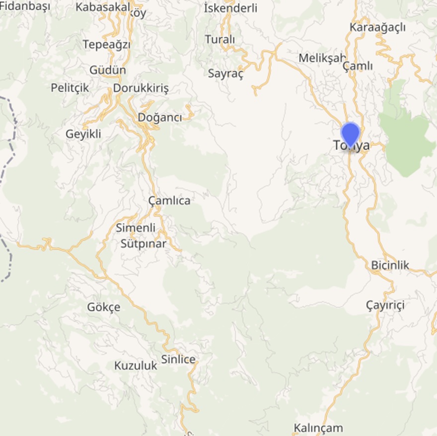 Fig. 2: Tonya (Kalinçam to Tonya = 10 km; Source)
Tonya Today
Tonya has a population of about 6,420 residents (2022 estimate, Source/). The backbone of Tonya's culture is its highland tradition. During the summer months, a significant portion of the district’s families move to the high plateaus, primarily Kadirga and Kadiralak. While engaging in grazing livestock on the plateau, they also gather with their neighbours to the sound of the kemençe and traditional horon dance. The Kadirga Otçu Festival is one of Tonya's oldest and most established gatherings; every July, it brings together thousands of people from Tonya, Of, Sürmene and surrounding districts. Tonya has made the Kadiralak Plateau Blue Star Flower Festival a tradition. For the people of Tonya, the plateaus are also where they recreate their identity, language and shared memory (Source).
The Tonya district features terrain with elevations up to 2,000 m. The mountains provide hiking trails known for their scenic vistas. Outdoor pursuits include autumn foraging in hazelnut and chestnut groves and winter snowshoeing on lower slopes during snowfall. Spring wildflower blooms attract botanists to highland meadows, while summer offers paragliding from regional peaks (Source).
Notes
Note 1
An example of vendettas by Tonyalis (people from Tonya) occurred in Livera,4 5 km south-east of Maçka (Fig. 1), which was composed of the Tonyali and Oflu (east of Trabzon), who had migrated there after the Greeks left Anatolia in 1923. The town was repopulated with migrants from the highlands of Tonya and surrounding villages. The properties of Greeks were the source of fights and even vendettas between the Tonyali and Oflu. Five years later, however, a decree stated that the rest of the abandoned Greek property would be allocated to the victims of a flood from the district of Of. State forces raided the squatted houses and banished the occupiers from the village. Ahmet, the new agha, assured the Of settlers that the allocated land would be under his protection. The Tonyali built new huts bordering the woods of Livera waiting to reclaim the land they had occupied before the Oflu settlers. The conflict between legal settlers, the Oflu and the occupying Tonyali, meanwhile, led to the rise of a new agha named Mahmut. Camps of animosity and alliance thus emerged: Ahmet Agha and his Oflu supporters versus Mahmut Agha and his Tonyali. Mostly fuelled by the fights over the abandoned Greek property, this sectarian divide would cause blood feuds until local government intervention in the late 1940s (Altun 2016:40–41, 44, 46).
Note 2
In 1185, the Byzantine emperor Andronikos I Komnenos and his eldest son Manuel were murdered. Later, in 1204, the Latins of the Fourth Crusade conquered Constantinople. Just before Constantinople fell, Manuel’s two sons, Alexios and David left for Georgia. From there, with a contingent provided by their aunt, queen Thamar, they occupied Trabzon and controlled an area as far as Sinope to the west. In 1214, the Seljuk Turks occupied Sinope and the small empire of Trebizond (1204–1461) was reduced to the east with its capital at Trabzon. It became an independent state separate from Constantinople. Its wealth and influence outstripped its size and population. The important transit trade via land and sea was very profitable due to the collected taxes collected on goods passing through Trabzon. The Komnenoi emperors of Trebizond were Greek by language, Eastern Roman by culture and Orthodox Christian by faith (Bryer and Winfield (1985); Nicol (1996)).
Note 3
From the late 17th century, timariots (military fiefs) and derebeys were effectively independent from the Ottoman central government in Istanbul. By the end of the 18th century, few Anatolian provinces were under the direct control of the central government (Source). The 14 Pontic derebey families along the Black Sea coast which arose, were primarily confined to one valley each. They were independent within their territories and brought anarchy to the Trabzon region.
Note 4
In the 11th century, when the Seljuk Turks invaded Anatolia, the Greek language spoken in the north-east corner of Anatolia became [more] isolated from other Greek speaking areas. There are hundreds of words in Pontic Greek that are unfamiliar to other Greek dialects (Mackridge 1987). So, it is not surprising that to Demotic Greek speakers (of Greece), Pontic Greek is generally incomprehensible.
The most archaic form of Pontic Greek i.e. Romeyka, has survived among the current Muslims from the Of region (east of Trabzon). This is a consequence of the pressure from the derebeys [feudal valley lords] in the 17th century who forced much of the populace to convert to Islam (Dawkins 1937). Professor Sitaridou states that due to the isolation of the mountain village communities, there is significant micro-variation within the regions where Romeyka is spoken (Source).
Acknowledgements
I warmly thank Micheal Bennett and Russell McCaskie for their comments to an earlier draft.
1. Words within square brackets ‘[ ]’ within a reference are the author’s words.
2. Kalinçam’s population is about 670 (2021; (https://tr.geoview.info/kalincam,744774).
3. Brendemoen (2002:280) indicates that the Romeyka Greek dialect of Çaykara (south of Of (Ophis) east of Trabzon) is substantially different from the Romeyka from Iskenderli (Kumyatak) north-west of Tonya.
4. See the author’s article on Livera at: https://pontosworld.com/index.php/history/sam-topalidis/937-a-brief-history-of-livera
References
Altun M (2016) Of conspiracies and men: the politics of evil in Turkey, PhD thesis, University of Minnesota, Minnesota, USA.
Brendemoen B (2002) The Turkish dialects of Trabzon: their phonology and historical development: I analysis, Harrassowitz Verlag, Wiesbaden, Germany.
Bryer A (1970) ‘The Tourkokratia in the Pontos: some problems and preliminary conclusions’, Neo-Hellenika, 1:30–54.
Bryer A and Winfield D (1985) The Byzantine monuments and topography of the Pontos, I, Dumbarton Oaks Research Library & Collection, Harvard University, Washington DC, USA.
Dawkins RM (1937) ‘The Pontic dialect of modern Greek in Asia Minor and Russia’, Transactions of the Philological Society,:15–52.
Mackridge P (1987) ‘Greek-speaking Moslems of north-east Turkey: prolegomena to a study of the Ophitic sub-dialect of Pontic’, Byzantine and modern Greek Studies, 11:115–137.
Nicol DM (1996) The Byzantine lady: ten portraits, 1250–1500, Cambridge University Press, Cambridge, England.
Roller DW (2020) Empire of the Black Sea: the rise and fall of the Mithridatic world, Oxford University Press, New York, USA.
Şerifoğlu TE and Bakan C (2015) ‘The Cide-Şenpazar region during the Hellenistic period (325/300–1 BC)’,:246–259, in Düring BS and Glatz C (eds) (2015) Kinetic landscapes: the Cide archaeological project: surveying the Turkish western Black Sea region, De Gruyter Open, Warsaw, Poland.