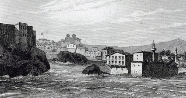
Trabzon 1839 (Texier, 1842 Wikimedia Commons).
By Sam Topalidis (2026)
(Pontic Historian and Ethnologist)
Introduction
The earliest historical evidence of Trabzon is that it was a Greek colony founded in the 6th century BC by Greeks from Sinope. At this time, however, there were indigenous Anatolian natives already living there. In 400 BC, it was visited by Xenophon and his nearly 10,000 Greek mercenaries on their way back to Greece. After 323 BC, with the death of Alexander the Great, Pontos (north-east corner of Anatolia adjacent the Black Sea, Fig. 1) came under the control of the Mithradatic Pontic kings (c.302–63 BC) who were of Persian descent. Early in Mithradates VI’s reign (119–63 BC), he probably captured Trabzon and in 64 BC, he was finally defeated by the Romans. Trabzon then came under Roman and then in the 4th century, Byzantine (Eastern Roman) control. In 1204, Alexios Komninos seized Trabzon from the Byzantines from Constantinople. In 1204–1461, the Komnenoi emperors of the small empire of Pontos controlled Trabzon and the area along the Pontic coastline. In 1461, emperor David Komnenos surrendered Trabzon to the Ottoman sultan Mehmed II. (For more background on Trabzon, see: pontosworld.com)
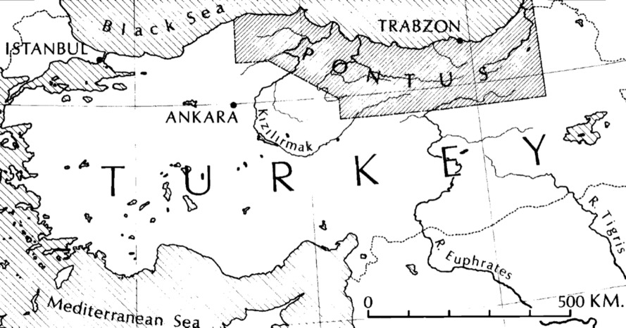
Fig. 1: Approximate boundaries of Pontos (Latin Pontus, Bryer and Winfield (1985:ii))
The formidable walled Trabzon saved the small empire on at least five occasions from Turkish invaders. By 1324, the walled town consisted of three connected enclosures, called the Lower City, the Middle City and the Citadel (Fig. 2). The Lower City is about 134,500 m2 in size (which increased to 220,900 m2 ), 20 m above it is the Middle City, of about 67,200 m2 . Finally, 950 m inland, 50 m above sea level and 40 m above the ravine beds below, lies the Citadel, of about 19,200 m2 (Bryer and Winfield (1985).
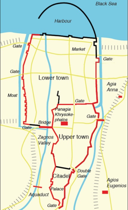
Fig. 2: Three walled sections of Trabzon (Khrysokephalos to Agios Eugenios = 450 m. (Source)
Traveller Observations Before 1461
Few Byzantine towns outside Constantinople can have their appearance assembled from literary sources alone. Trabzon under the Komnenoi emperors is an exception. Bryer and Winfield (1985:178–183) compiled a detailed description of Trabzon on the eve of 1461, which is summarised in the following paragraphs.
The voyager who approached Trabzon by sea from the west would reach the tower of the Orthodox monastery of St Sophia on the outskirts of the western suburb (Fig. 3). Looking ahead the traveller could see a long rock crowned by the walls of the town and stretching down to the sea and behind that the flanks of Boz Tepe (Grey Hill, about 243 m above sea level). The hills behind the western suburb were lower. But few signs of habitation could probably be seen among its gardens and orchards of grapes, walnuts, lemons and olives. Amid these orchards was probably the imperial polo pitch.
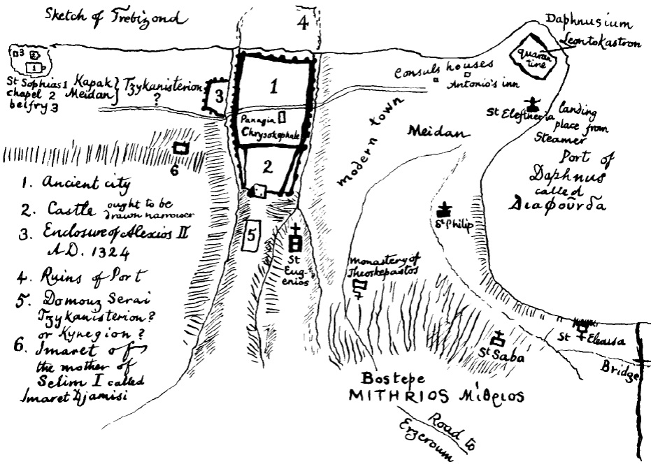
Fig. 3: Simple map of Trabzon (Finlay (1850) in Bryer and Winfield (1985: between 194–195)).
The western and eastern suburbs were divided by the walled town, a long narrow spur of rock defined by two steep ravines which run north to the sea, where they emerge on either side of a small imperial harbour, perhaps built by Roman emperor Hadrian (see 4 in Fig. 3). The western and eastern ravines were spanned by wooden bridges. In the walled town, the traveller would probably first see huddled houses. The houses climbed from the Lower City, which spread over the western ravine, to the Middle City, marked by the Orthodox church of the Chrysokephalos and up to the Citadel (Fig. 2). Here stood the palace of the Komnenoi emperors.
The traveller would sail on to the commercial harbour of Daphnous, beyond the eastern suburb, the main commercial quarter of Trabzon. The suburb, running from the walled town to Daphnous, was divided into two parts: the strip north of the imperial way, given over to Italians, with the massive Genoese castle of Leontokastron at the corner of Daphnous and the more modest Venetian establishment to the west. The bazaar also lay between the imperial way and the sea. Here also were workshops, warehouses and caravansarays. To the south of the Imperial way lay many Greek churches.1 Here, beneath Boz Tepe, the traveller could make out the St Eugenios church, the Theoskepastos monastery (on Boz Tepe) and built into the Mithraic tombs of Boz Tepe, St Sabbas’ chapels.
In the Daphnous harbour, to the traveller’s left was the delta of the modern Degirmen River. Below the cliffs of Boz Tepe, the shore was lined with warehouses, arsenals, sheds and stables to entice the caravans. Skiffs would come out to meet the traveller who would land below the Meydan. In the Italian stations he would find baths, furnaces, chapels and Greek customs officials. In the imperial way between the Meydan and the walled town he would pass Mingrelians, Circassians, Turks, Georgians, Venetians, Laz, Greeks, Tatars and Armenians. Clavijo gave a description of Trabzon in 1404:
Trabzon is built near the sea, and its wall rises up over some rocks, and on the highest part there is a strong castle, which has another wall around it. A small river passes by the castle, and dashes over the rocks, and on this side the city is very strong, but on the other side it is open ground. Outside the city walls there are suburbs, and the most beautiful part is a street near the sea, which is one of these suburbs, where they sell all the things required in the city. On the shore there are two castles, with strong walls and towers, one belonging to the Venetians the other to the Genoese, and they hold them with the consent of the emperor. Outside the city, there are many churches and monasteries (Clavijo 1859:62–63).
Despite having up to 19 churches2 , Christian Trabzon did not number much more than 4,000 souls on the eve of 1461. The population would swell on market days and festivals and when the caravans assembled or struggled in from Persia. But in times of plague in the late 14th century, or during Turkmen attack, its people would make for the hills.
Traveller Observations After 1461
Tournefort 1701
Tournefort (1741:71–72) found the town to be big but not well peopled. It had woods and gardens and houses which were only one storey high. The castle was much neglected and was situated upon a flat rock. He noted St Sophia, the ancient Greek church, part of which had been turned into a mosque, the rest in ruins.
Brant 1835
Brant (1836:189–190) states that there was no evidence of buildings older than the Christian era. There were however, nearly 20 Greek churches and chapels. The handsomest was St Sophia, which was still in a good state externally and although it had been converted into a mosque, it was seldom used.
Brant noted that the town was built on the slope of a hill facing the sea, part of which was surrounded by a lofty wall with battlements in the shape of a parallelogram. On either side of the walled portion of the town was a deep ravine, filled with trees and gardens and both ravines were traversed by bridges. Overlooking the town was a neglected Citadel.
Below the town was a small port, intended probably for row-galleys. The beach between the town and the sea was enclosed by the walls of the town on both its sides which extended as far as the quays. The quays surrounded the whole port, leaving only a narrow entrance: the upper parts had been washed away, but enough of the masonry remained under water to give protection to boats which still used the port.
A small open bay at the eastern extremity of the town was used as an anchorage during the summer. After the autumnal equinox, vessels used Platana, to the west of Trabzon.
The houses of the town had a yard or a garden with a few fruit trees and from the sea the town had the appearance of a forest when the trees were in leaf. The walled part of the town was inhabited by Muslims and outside the walls contained the Christian population, some Muslim families, as well as the bazars and khans.
The locals were unfriendly to Europeans.
Hamilton 1836
Hamilton (1842:159–162) described the location of Trabzon as remarkable. It was built at the foot of a high range of undulating hills, sloping gently to the beach and was well-wooded. The houses, outside the walled town at least, were interspersed amongst trees and gardens. On a small projecting rock were the ruins of a castle (Plate 1). Trabzon contained neither inns nor lodging-houses and the streets were the narrowest he had ever seen.
The principal articles of trade were alum and copper brought from the mines in the interior. The latter was manufactured into articles for domestic or culinary purposes.
The position of the walled town was very picturesque, bounded to the east and west by rocky ravines of considerable depth, while the summits were fringed with the impressive ruins of the Byzantine walls, with turrets and battlements, above the mass of foliage. This part of the town was connected with the suburbs by a high bridge on each side and was defended by strongly-fortified gateways above. Hamilton observed that an old and picturesque castle, the outer walls of which were of a great height occupied the ground between the two ravines.
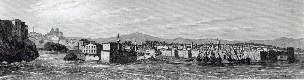
Plate 1: Trabzon 1839 (Texier (1842) Wikimedia Commons)
Sandwith 1854
Sandwith (1856:16–17) observed that viewed from his vessel, Trabzon was picturesque in the extreme. The country was rich in vegetation. As soon as his steamer cast anchor, a crowd of large boats, rowed by big-turbaned Turks raced towards his vessel and rowed him ashore. The estimated size of the population was probably upwards of 20,000 but more difficult was to determine the proportion of Armenians, Greeks and Muslims, though the latter were by far the most numerous.
Tozer 1879
Tozer (1881:449–452) stated he approached pretty Trabzon from the east. To the west of the mouth of the stream, a low promontory jutted northward into the sea, forming a bay. He continued that the eastern side of this headland, except the extremity remained a bare rock and was sprinkled with houses with tiled roofs and painted in different colours; with gardens, while the summit was crowned by a long line of tall cypress trees, the site of an old cemetery. These buildings belonged to a suburb, for the main part of the town was not visible from that side. When he entered, it was a lively neighbourhood from the number of caravans that might be seen starting for the interior, especially for Persia, for the landing-place from steamers was in close proximity and a motley effect was produced by the dresses of the various nationalities. To the west of this suburb stretched the extensive Christian quarter and beyond this again was the walled town.
The walled town was very remarkable. Two deep valleys, descended from the interior, running parallel down to the sea, inclosing between them a sloping table of ground—which falls in steep rocky precipices on two sides. The whole was enclosed by the Byzantine walls. Tozer found it difficult to conceive anything more picturesque than these fortifications and their surroundings. Its position relatively to the interior of Asia rendered it a flourishing commercial emporium.
Hepworth 1897
In a brief extract, in Trabzon there were old walls, broken towers and other relics to be seen. It was not frequented by tourists and while wandering through the town Hepworth had the feeling of being in a fairyland (Hepworth 1898: 51–53, 57).
Curtis 1910
Curtis found it difficult to conceive anything more picturesque than the ancient walls and towers. From the ship he saw the mouths of cannon from the top of a castle. Passengers and cargo were handled at a small pier extending beyond the breakers and it was a nasty place for people to land. West of the walled town the church of St Sophia must have been a magnificent structure. The pavement of many-coloured marble was very beautiful and the walls were decorated with pictures in mosaic, although the vandals had covered them with whitewash (Curtis 1911:29–31).
Pereira late 1960s
Pereira (1971:240–244) described Trabzon as expanding, alive, busy and a little impatient. There was still much that was old and attractive. One of the most beautiful Byzantine buildings outside of Istanbul was the former Orthodox church of St Sophia. Noting that the magnificent frescoes had been restored by David Winfield and his team, it was a museum (from 1964). The former Orthodox churches of Chrysokephalos and St Eugenios were operating mosques and both had undergone little alteration in being converted to mosques and were worth visiting.
The Citadel was a main attraction and enough of it was still standing to give an idea of its former magnificence. On the whole, Ottoman remnants in the town were surprisingly poor.
Periera argues that Trabzon grows slowly upon one’s affections: it hides its charms lurking in narrow, back-streets which the casual traveller will never see and reveal themselves in sunsets. On the other hand, the town was functional rather than beautiful. Pursuits included agriculture (mainly hazelnuts) and fishing (the most famous being hamsi). Two other important crops included tobacco and maize.
Conclusion
From its foundation as a Greek colony in the 6th century BC, Trabzon has a long documented history and has fascinated travellers for centuries. Trabzon was the ancient capital of the Greek speaking Komnenos Byzantine Trebizond kingdom (1204–1461) in Pontos. It was a strategic and commercially important easterly port through which European trade could once reach a major overland route over the Pontic Alps to and from Persia.
Its longevity was influenced by its remote location hemmed against the Black Sea by the Pontic Alps with its well-fortified town and the strategic marriages made with its neighbours. In 1461, it surrendered to the Ottoman sultan Mehmed II.
Acknowledgements
I wish to thank Michael Bennett and Russell McCaskie for their comments to an earlier draft.
1 See the author’s detailed article on Greek churches in Trabzon at: pontosworld.com
2 The earliest evidence of a church in the town is before 884–885, when St Anne was rebuilt.
References
Brant J (1836) ‘XIV —journey through a part of Armenia and Asia Minor, in the year 1835. Communicated by James Brant, esq. His majesty’s consul at Erz-rum. July 1836’, The Journal of the Royal Geographical Society of London, 6:187–223.
Bryer A and Winfield D (1985) The Byzantine monuments and topography of the Pontos, I, Dumbarton Oaks Research Library & Collection, Harvard University, Washington DC, USA.
Curtis WE (1911) Around the Black Sea; Asia Minor, Armenia, Caucasus, Circassia, Daghestan, the Crimea, Roumania, Hodder & Stoughton, New York.
De Clavijo RG (1859) Narrative of the embassy of Ruy Gonzalez de Clavijo to the court of Timour at Samarcand A.D. 1403–6, (Translated in 1859 from Spanish 1582 text by Clements R Markham. Reprinted in 2005 from the 1859 edition by the Hakluyt Society) Elibron Classics, London.
Hamilton WJ (1842) Researches in Asia Minor, Pontus and Armenia: with some account of their antiquities and geology, 1, John Murray, London, reprinted by the University of Michigan Library in 2009.
Hepworth GH (1898) Through Armenia on horseback, Isbister and Company Limited, London.
Pereira M (1971) East of Trebizond, Geofry Bles, London, England.
Sandwith H (1856) A narrative of the siege of Kars, John Murray, London.
Texier CFM (1842) Description de l’Armenie, la Perse et la Mesopotamie, (in French) Paris.
Tournefort JP de (1741) A voyage into the Levant, III, letter v, (translated from French to English by Ozell J), originally published 1717, London.
Tozer HF (1881) Turkish Armenia and eastern Asia Minor, Longmans, Green and Co., London.